Preparing for a Top Roping Outing
Following completion of the design phase, it is important to then communicate with participants and prepare for the top roping day. Participants who possess a clear understanding of the day's logistics, activities, and expectations will be far better equipped to achieve the outing objectives. In this chapter we will explore the key information that needs to be conveyed to participants, the requisite weather related information that the top rope leader should research, and the required decision making process as to whether or not to proceed with the outing based on that research.
Coordinating and Communicating with Participants
Early in the preparation stage it is important to coordinate and communicate with participants. This provides them with sufficient time to ensure the trip is suitable for their skill level, they meet any prerequisite requirements, and they are capable of appropriately equipping themselves for the day and arranging transportation to the climbing venue. There are many ways to communicate to participants, however, email is one of the simplest methods to ensure all participants receive consistent and accurate information. Information that must be communicated to participants includes:
- Meeting time;
- Meeting location (parking lot for well established venues, carpool locations, or restaurant/coffee shop, etc.);
- Top rope leader contact information (cell phone number, email);
- Level of risk specific to the activity (site considerations, difficulty of the climbing, and access concerns);
- Prerequisite requirements (previous top roping climbing experience, ability to climb a specific grade, minimum age, etc.)
- Clothing requirements for the day (include clothing list for participants);
- Equipment requirements for the day (include equipment list for participants); and
- Contingency plans for the day (nearby alternate venues, climbing gym, trip cancellation).
Gathering Weather Information
One of the greatest factors in determining the success of a top roping outing, and the level of risk the outing will present, is the weather. Warm, dry, and calm conditions are by far preferable to cool, wet, and windy days when climbing. Being able to anticipate weather occurrences and changes for the duration of the outing enables the top rope leader to adapt the objectives, location, or timing of the outing to increase participant enjoyment and success while also decreasing the level of risk.
Resources for Gathering Weather Information
Current, short-range, and long-range weather forecasts can be quickly accessed online through a variety of sources. During periods of stable and predictable weather, these forecasts tend to be quite accurate and highly reliable. However, during periods of instability or changing weather, the forecasts and modelling upon which they are based, become less reliable and the top rope leader may need to complete further research to obtain an accurate depiction of the weather systems that will affect the outing.
Resources for Obtaining a Basic Weather Forecast
- Environment Canada weather.gc.ca (radar, satellite, and jet stream mapping);
- The Weather Network theweathernetwork.com/ca;
- Accuweather accuweather.com;
- Spot Weather Forecast spotwx.com;
- Televised weather stations; and
- Weather Radio Canada: frequency (MHz) 162.40
Resources for Obtaining a More Detailed Understanding of the Weather Systems
- Environment Canada weather.gc.ca/radar.
Understanding Basic Weather
Weather is a combination of atmospheric pressure, atmospheric humidity, air temperature, elevation, and wind. These variables combine to create localized weather systems, widespread weather patterns, and changes in weather conditions. In the context of preparing for a top roping outing, it is crucial that the top rope leader explore the weather forecast, and at times complete further research to obtain a solid understanding of the anticipated weather for the day. Widespread weather systems are typically easy to predict, however localized weather can at times be more challenging. Understanding if the weather will be poor for an entire day, or just for brief periods during the day, will enable the top rope leader to determine if they should proceed with the trip, reschedule, or implement contingency plans.
Atmospheric Pressure
Atmospheric pressure is essentially the measurement of air density and is commonly measured in either hectopascals, kilopascals, or millibars. Atmospheric pressure gives an overall sense of the widespread weather systems throughout a region, and is commonly viewed on a large scale pressure map that enables the viewer to identify areas of both high and low pressure.
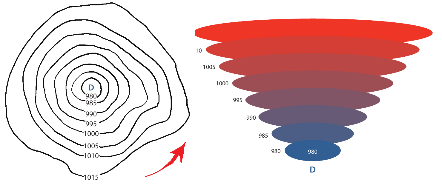
As air warms it rises and expands creating lower pressure at the earth's surface. The continual upward movement of the air mass can create strong winds and overall instability of the pressure centre. Warm air tends to be more humid and as it rises and cools, precipitation often develops. During the summer months this precipitation comes in the form of rain and thunderstorms, and in the winter months, it comes in the form of snow. A low pressure system will show increasing pressure outward when viewed on a large scale pressure map.
Jet streams are narrow bands of strong wind high in the atmosphere that steer weather systems and transfer heat and moisture around the globe. The local weather that we experience is related to high and low pressure systems and fronts, however, jet streams high in the atmosphere impact their movement and impact their trajectory and speed.
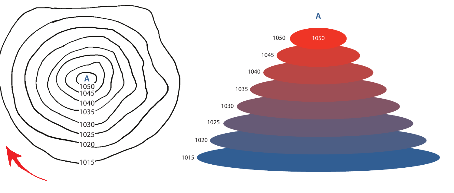
As air cools it contracts creating higher pressure at the earth's surface. A high pressure system draws air downwards often creating calm wind conditions and overall stability of the air mass. Cool air tends to be dry and lack humidity, therefore, a high pressure system is typically not characterized by notable precipitation. A high pressure system in the summer usually offers calm, comfortable climbing conditions, whereas in the winter a high pressure system may bring with it extreme cold and clear conditions. A high pressure system will show decreasing pressure outward when viewed on a large scale pressure map.
Decreasing pressure often signifies worsening weather conditions, whereas rising atmospheric pressure tends to indicate improving conditions. A rapid change in the pressure often signifies a shorter but more intense shift in the weather, whereas a slow and steady change in the pressure typically indicates a change that will last for an extended period of time. Changes in the atmospheric pressure are typically characterized by both ground and high level winds.
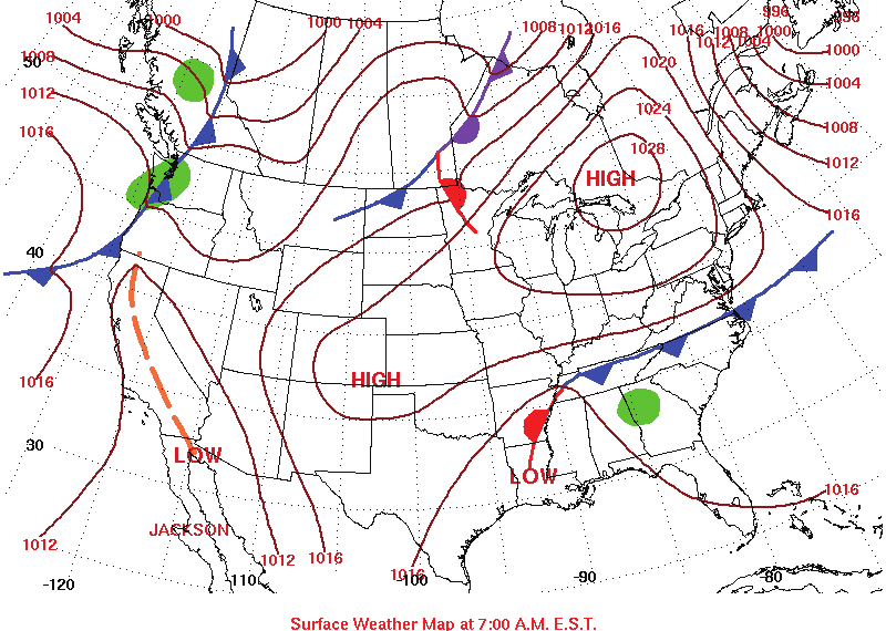
The location where two air masses converge is referred to as a front. Fronts are often depicted on weather maps with modelling that illustrates the anticipated trajectory and speed of the front. Cold fronts are typically shown in blue to delineate where a cold air mass is replacing a warm air mass, whereas warm fronts are typically shown in red to define warm air replacing cold air.
As pressure systems travel across the earth they do not move in straight lines. The rotation of the earth, the earth's strata, and high level atmosphere winds, such as jet streams, cause rotation in the air mass, and weather systems that are circulating in nature.
Interpreting Clouds
The ability to identify and understand cloud formations will assist the top rope leader in identifying changes in the weather prior to their top roping outing, as well as throughout the day. Clouds are commonly categorized as either cumulus which indicate a vertical development, or stratus, which are clouds that form horizontally. Clouds between 2000-6000 metres, are commonly given the prefix 'alto' whereas clouds above 6000 metres are coined 'cirrus'.
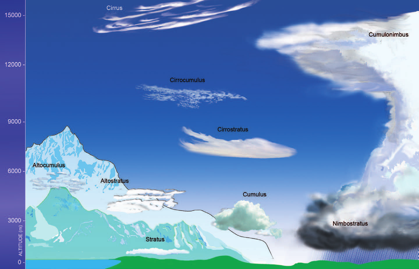
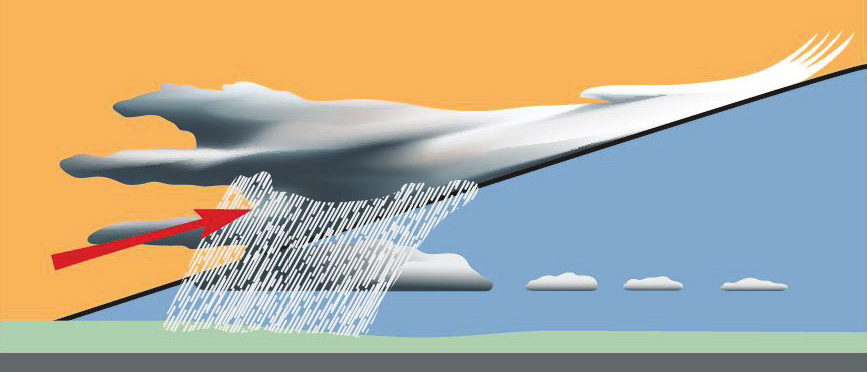
Different cloud formations indicate the arrival of different weather systems. High cirrus clouds will be visible prior to the arrival of a low pressure system or warm front. Cirrus clouds will commonly be visible before the weather changes are felt at a ground level. Initial cirrus cloud formation will precede the ground level weather changes because the warm air mass moving in is less dense and will overlay the cooler air mass. The initial high cirrus clouds are commonly followed by cirrostratus clouds, altostratus clouds, and eventually stratus, and nimbostratus clouds, which commonly bring rain or snow events.
Conversely, the arrival of a high pressure system or cold front is often characterized by a decrease in visibility and the development of alto stratus and cumulus clouds in a chain-like configuration. Weather changes at ground level are often felt quite quickly as the cold air mass pushes the warm air mass on top of it. This causes rapid cooling of the warm air as it gains elevation and nearly immediate precipitation.
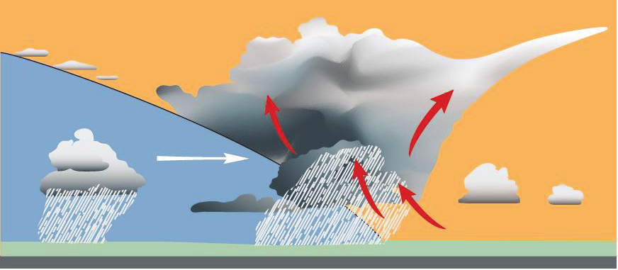
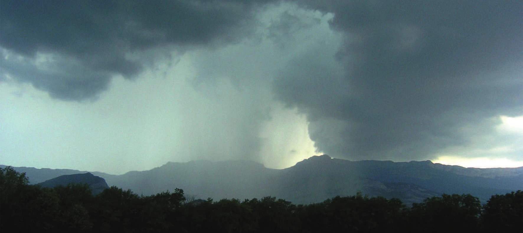
One of the more significant weather related risks to a top roping outing is a thunder or electrical storm. Thunder storms are easily visible forming in the sky, the formation of small cumulus clouds that gradually rise and develop into cumulonimbus clouds are a marked sign of the development of isolated thunder storms. Large cumulonimbus clouds with dark bases indicate an imminent thunder storm and a need for the leader to manage the group accordingly. In the field, is important to differentiate between cumulonimbus and cumulus clouds, as the formation of cumulus clouds that lack vertical development is often insignificant and non-indicative of the formation of a thunderstorm.
In the event that a top roping outing is caught in an electrical storm, the following precautions should be taken:
- Avoid being the highest point in the surrounding landscape;
- Stay away from water;
- Stay away from objects that conduct electricity;
- Seek shelter in low-lying areas under a thick growth of small trees or bushes; and
- Insulate yourself from the ground by sitting on your pack.
Weather and Potential Impacts or Risks on a Trip
Regardless of the forecast, the weather will have an impact and affect on the top roping outing. Warm and dry conditions, while ideal for climbing, often lead to crowding at popular venues, potential heat and sun related illnesses, and increased rock fall following an overnight freeze. Conversely, cool and damp conditions present cold related illness risks, slippery routes and access trails, and increased rock fall. Windy conditions also present a risk in the form of unanticipated dehydration, wind chills, increased rock fall, and communication challenges. A top rope leader needs to be acutely aware of the risks the weather presents and the impact they may have on the outing, and ensure risks are appropriately mitigated.
Pre-Trip Risk Assessment
Prior to proceeding with a top roping outing it is important to complete a pre-trip risk assessment to determine the viability of the outing. The pre-trip risk assessment involves examining the weather forecast and data, the current weather conditions, the objectives of the outing, and the knowledge and experience of the top rope leader and the group to determine a course of action. Periods of predictable and desirable weather matched with dry conditions, realistic objectives, and appropriate leader and group knowledge would demonstrate a likelihood to proceed with the trip as planned. Whereas periods of weather instability, poor existing conditions, unrealistic objectives, or a lack of knowledge on the part of the top rope leader or the group might necessitate a re-examination of the anticipated outing and adjustment to the itinerary.
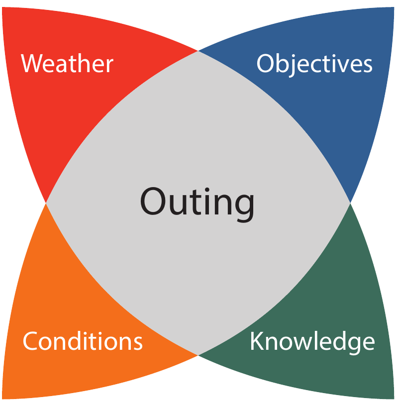
A top rope leader is responsible for ensuring that risks are well managed and appropriate for the participants throughout the trip. When completing the pre-trip risk assessment and calculating the risks, it is important for the top rope leader to determine their course of action based on their participants' abilities and risk tolerance. While the leader themselves may personally be comfortable proceeding with a top roping outing during periods of weather instability, proceeding with the outing in less than optimal conditions may be beyond the comfort level of the participants.
Weather Monitoring During a Top Roping Outing
Even during periods of weather stability, top rope leaders should routinely monitor the weather for changing conditions throughout the day. Small localized storms are common in mountain environments. Key elements to monitor throughout the day would include; notable changes in the wind strength and direction, significant changes in temperature, significant cloud formation, presence of thunder and/or lightning, and rapid changes in the atmospheric pressure.